Your cart is currently empty!

Orthorectification of Aerial Images
If you’re here, you’re likely seeking insights on orthorectifying aerial images or delving into the concept of orthorectification itself. Our team at Orthophoto.io has crafted a series of blog posts tailored to introduce you to orthorectification and explore advanced concepts. In this blog post, you will find out how this method rectifies distortions, ensuring each pixel accurately reflects its ground area. Moreover, how does orthorectification enhance decision-making and deepen our understanding of geographical features? Let’s explore the significance and mechanisms of orthorectification in unlocking the true potential of aerial imagery.
Why do we need orthorectification?
Orthorectification serves as a critical process in aerial imaging, addressing inherent distortions arising from factors such as the Earth’s curvature, terrain variations, and camera angles. By rectifying these distortions, orthorectification ensures that each pixel in the image accurately corresponds to a consistent ground area, aligning the imagery with precise geospatial coordinates.
The significance of orthorectification lies in its ability to deliver geospatial accuracy essential for applications like terrain mapping, agricultural monitoring, and urban development assessment. By facilitating precise measurements and analyses, orthorectified images empower planners, engineers, and analysts to make well-informed decisions based on reliable, ultra-high-resolution spatial data. Moreover, orthorectified imagery can be integrated seamlessly into Geographic Information Systems (GIS), streamlining workflows for spatial analysis and visualization professionals. In essence, orthorectification enhances the usability and reliability of aerial imagery, offering a foundational tool for leveraging geospatial information in corporate and institutional contexts.
Theoretical background
Aerial photos in their basic form are unsuitable for direct use in surveying or geodetic applications. This is due to their non-uniform scale, which varies from point to point, and their lack of adherence to a Coordinate Reference System (CRS). As a result, measurements of distance, angle, or area made using conventional surveying or GIS software may be inaccurate. Moreover, high-precision GIS applications require alignment with local or national Coordinate Reference Systems (CRS), necessitating the transformation of aerial photos before extracting reliable metric information.
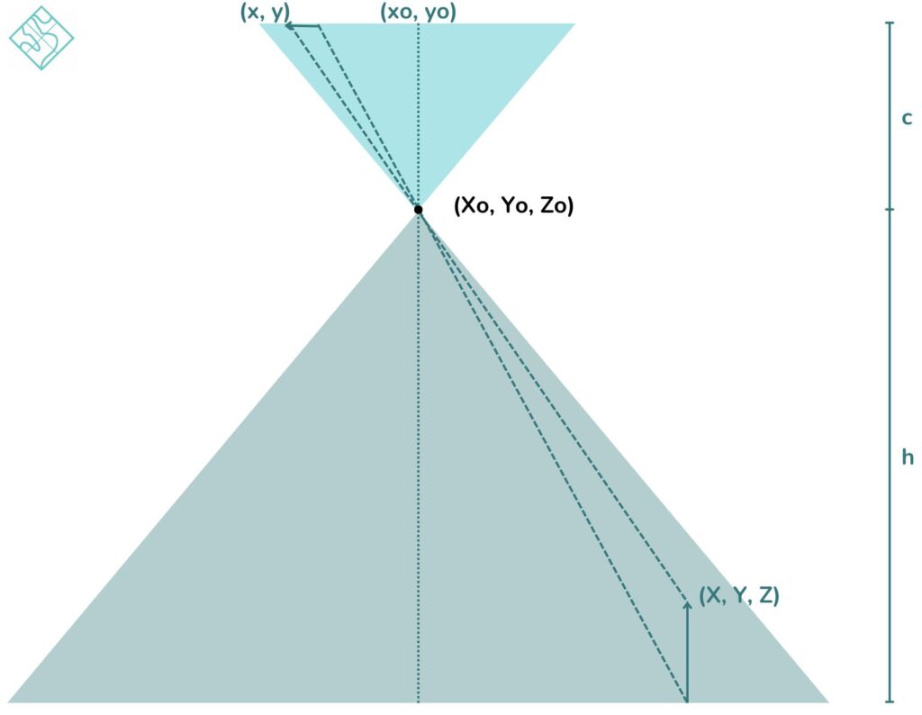
An aerial photo follows the pin-hole camera model. This model dictates that during image acquisition, all-optical beams converge through a single point known as the principal point, situated at the center of the shutter. It’s worth noting that this principal point also serves as the focal center for the Camera Coordinate Reference System (CCRS).

Thus, the following elements:
- Physical point of Interest (X, Y, Z / CRS-related)
- Principal Point / Shutter center (Xo, Yo, Zo in 3D-Space, xo, yo in Camera Space)
- Point in the camera (x, y)
belong on the same line (collinearity condition), expressed by the following equations:
x = xo – c R11(X-Xo) + R12(Y-Yo) + R13(Z-Zo)R31(X-Xo) + R32(Y-Yo) + R33(Z-Zo)(1)
y =yo – c R21(X-Xo) + R22(Y-Yo) + R23(Z-Zo)R31(X-Xo) + R32(Y-Yo) + R33(Z-Zo)(2)
where:
- c is the focal length i.e. the distance between the shutter center and the camera plain
- Rij are elements of a 3×3 rotation matrix since the camera plane can have up to three (3) rotations (ω, φ, κ) relative to the 3D-Space/CRS.
Thus, through orthorectification, an aerial image undergoes geometric correction and is then projected into a Coordinate Reference System (CRS). This correction accounts for various camera distortions, including shrinking, errors in principal point coordinates, and radial distortion, as well as compensating for topographic relief. Ultimately, orthorectification enables the extraction of metrics aligned with the CRS, ensuring accuracy and reliability in spatial analysis and interpretation.
We want to hear from you! Have questions about orthorectification? Suggestions for future topics? Or perhaps you have a success story to share? Drop us a message, and let’s make this space a hub of shared knowledge and collaboration.


